Google Earth 2024
10.64.0.6 Latest version
Satellite map

Google Earth Android mobile version, also known as Google Earth software. Google Earth is a software that allows you to experience VR panoramic views, which supports various regions and offers a 360 degree experience. If using VR devices, you can feel as if you are in person. If you are interested, you can try it out!
A Android virtual Earth software officially launched by Google, with powerful features that allow you to explore the world in more detail. The powerful street view function allows you to visit countless scenic spots around the world without leaving your home, and supports satellite images, maps, terrain, and 3D buildings.
By using it, we can not only browse various elements such as roads, boundaries, locations, terrain, but also discover real-time map details such as earthquakes, flying planes, and urban tourism routes. At the same time, the new navigation function in the software can select virtual travel routes and real 3D virtual buildings from anywhere in the world, allowing you to travel around the world without leaving your home.
In addition, the all-new Google Earth mobile version even adds a new "tour guide" function. Simply swipe the label at the bottom of the screen to easily explore exciting new places, so you can browse a series of selected virtual travel routes around the world. There is also a lunar exploration function to see the true appearance of the moon, but it is worth noting that some models are not compatible. Users who need it are welcome to download and collect it for free.
How to view buildings around the world on Google Earth
Open the software, move two fingers in the view to rotate the earth, drag down two fingers to tilt the view, and point both hands left and right to zoom in on the view;
Click on the humanoid icon below the map to enter street view mode, and click on the pointer icon to immediately lock the north direction;
Enter the address in the search box above to quickly access the map of the area;
When viewing a map of a certain area, a 3D icon will appear in the lower left corner when the camera is zoomed in close enough. Clicking on this icon can achieve the conversion between 2D and 3D in that scene;
Click on the measuring instrument icon in the upper right corner to measure the distance between the set two points;
Click on the three dot markers in the upper right corner to view your current location, share your location, and create postcards;
Click on the three horizontal lines in the upper left corner to access special features such as Google Earth login and My Location;
How to use Google Earth mobile version tutorial
Open the software and place two fingers in the view to rotate the Earth. Drag down to tilt the view, and point left and right to zoom in;
Click on the humanoid icon below the map to enter street view mode, and click on the pointer icon to immediately lock in the north direction;
Enter the address in the search box above to quickly access the map of the region;
When viewing a map of a certain region, when the lens zooms in close enough, a 3D symbol will appear in the lower left corner. Clicking this symbol can achieve the mutual conversion between 2D and 3D of the scene;
Click on the measuring instrument icon in the upper right corner to measure the distance before setting two points;
Click on the three dots in the upper right corner to view your current location, share your location, and create a postcard;
Click on the three horizontal lines in the upper left corner to access special features such as Google Earth login and My Location;
Because Google does not have servers in China, it can lead to slow loading.
New features
Use the Explorer feature to choose your own exclusive exploration journey.
Experience interactive stories from around the world.
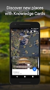
Discover new locations through "knowledge cards".
Explore the information card to learn more about local landmarks.
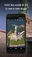
View the world in 3D mode.
Use new 3D buttons or tilt the map with two fingers.
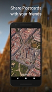
Take and share postcards.
Take a snapshot of the location and share it with friends.
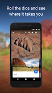
Good luck?
Roll dice and explore unknown locations.
How to use it
Draw on the map
Add landmarks to highlight key locations in the project, or draw lines and shapes directly on the map.
Add photos and videos
Display images and videos on your map to add rich background information.
Customize your view
Tilt the map for a perfect 3D landscape, or delve deeper into street views to enjoy a 360 degree all around experience, using Google Earth as a meticulous globe.
Share your story with the world
You can collaborate with others, just like collaborating in Google Docs, or share your story in the form of a presentation.
App information
1. Provide detailed information on over 100 million locations
2. Provide comprehensive and accurate maps of 220 countries/regions
3. Bus routes and maps in over 15000 towns
4. Can provide GPS voice navigation for driving, cycling, and walking routes
5. Provide street views and indoor images of restaurants, museums, and other locations
6. Provide real-time road condition information, accident reports, and automatic rerouting functions to help you find the best route
- App Name
- Google Earth
- Version
- 10.64.0.6
- Size
- 11.05M
- Date
- Oct 08, 2024
- Genre
- Navigation Apps
- Requirements
- Android 8.0+
Similar Apps

